One of the best things about hiking is being reminded of how insignificant we are. The most obvious places for this are Yosemite and The Grand Canyon. They're indescribably huge and perfectly constructed and they make you feel like it's okay to be relatively useless.
Less obvious is the tallest mountain in the contiguous US, Mount Whitney. Driving up from Los Angeles, the mountain starts to come into view when you reach the town of Lone Pine and it's not all that impressive. The perspective makes it and the nearly 3-mile tall mountains that surround it look only slightly taller than the cute little Sierra foothills in front of them.
Once you get into the Alabama Hills and closer to the mountain, it starts to look as monstrous as it really is.
From the Whitney Portal campground, you finally realize that you're seeing a 14,505' mountain and (at least in my case) the tallest thing you've ever seen in person. You're surrounded by Sierra peaks and ridges.

As always, Matt and I did our research before doing this 22 mile hike so we knew that two days acclimatizing at the 8365' campground would be essential if we wanted to make it to the summit without getting sick. From what I read, I was expecting the campground to be full of hikers preparing to cross Mt. Whitney off their peak lists, but it ended up being one the most peaceful and relaxing campgrounds I've ever been to. It's right by Lone Pine Creek and the sound of the creek is pretty much the only thing you can hear. Somehow, even though almost all of the sites are taken, you rarely hear your neighbors. The humans are great, but the animals can get aggressive and annoying whenever there's food around. Any time you eat, yellow jackets will surround you try to share your food, and there are signs everywhere warning you to make sure to get your food put away before dark so the bears don't get to it.

The signs are no joke. This guy walked right up to our bear locker when we were putting our dinner away just as the sun was going down.
While sleeping at 8000' is helpful in acclimating to the altitude, it's also supposed to be a good idea to spend the two days before climbing Whitney taking shorter hikes up to higher elevations. Our first day there, we took an easy 5 mile hike on the Mt. Whitney Trail to another incredibly peaceful spot, Lone Pine Lake. It's just under 10,000' so it's a good place to go to hang out in the thin air (but you can't go past the lake without a permit). You also get a preview of the trail you're going to be on for the big hike, which is especially helpful if you're planning on starting the hike before sunrise.
There are unfortunately not a lot of other options for last minute training and acclimating hikes in the area (but if you're up for driving about 20 miles, the rangers at the visitor center recommend
Kearsarge Pass Trail).
We went for the Meysan Lake Trail instead. According to our map, there are several lakes on the way so we were hoping we could get to one without having to climb 4.7 miles all the way to Meysan Lake.
The trail gave us a good workout and a nice view of the town of Lone Pine but at around 4 miles and just under 11,000 when we still weren't able to find a lake, we decided we'd had enough and didn't want to wear ourselves out the day before the big hike.
Most of the trip reports and people we talked to beforehand recommended starting the dayhike around 3am so that we could take our time and still get back to the trailhead before dark (although it's not really a problem if you don't make it before dark since you have the headlamps/flashlights for the start of the hike anyway). The early start time is also to ensure that you make it to the summit before noon to avoid thunderstorms, but we were lucky enough to have perfect weather. The average dayhike time seemed to be around 15 hours, but we weren't trying to break any records; our only objectives were to have a fun and challenging hike, see some great views, and hopefully make it to the summit without any injuries or sickness.

I never thought my first night hike would be on the Mt. Whitney trail. It was creepy at times, but there were other hikers behind and ahead of us. It's strange to wake up at 2am and find that half of your camping neighbors are also awake preparing for the same ridiculous dayhike as you. It was comforting to know that we wouldn't be hiking alone in the dark.
The only bad thing about starting when everyone else starts is that it's harder to find a private rock to squat behind once the sun comes up.
Our start time ended up being just right for getting the perfect view of the sunrise. This, not the summit, was by far my favorite part of the hike. I've never felt smaller.
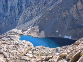
At 6.3 miles, we were more than halfway to the summit and took a long snack break at trail camp. This is where most of the hikers who are lucky enough to score an overnight permit set up their tents. Once we reached trail camp, we were officially at our highest elevation ever, 12,000'. If you're not feeling any symptoms of altitude sickness, that's probably a good sign that you've acclimated sufficiently. If you're filtering or treating water, this is the last place to get it (we ended up drinking around 3 liters each). Don't get too excited, the second half is much more challenging than the first.
 |
| The lake at trail camp | | | | | |
|
The 97+ switchbacks weren't quite as tedious as I expected. You can look back at trail camp and watch all the tents get smaller and smaller, and then look up as trail crest keeps getting closer and you finally see your destination come into view. There's no real threat of slipping off the trail at this time of year, but the fall down to trail camp is so far that it's still kind of scary in spots.
 |
| Sauntering our way up the switchbacks |
 |
| The cables - not very dangerous at the end of August |
 |
| Consultation Lake |
 |
| Needles and Whitney |
Just when you start getting sick of the views on the switchbacks, you reach trail crest at 13,600', my second favorite moment of the hike: you round a corner and suddenly an entirely new breathtaking subrange comes into view.
 |
| Trail Crest |
 |
| Mt. Hitchcock and Hitchcock Lakes |
Based on the numbers (only 900' left!), you'd think the toughest part of the hike was behind you, but the final 2.5 miles feels like the hardest, mostly because of the altitude. The trail isn't very narrow, but the drop is so inconceivably far down that you have to put all of your concentration into keeping your footing.
 |
| Mt. Whitney window |
|
Just to add to your anxiety, there are several "windows" along this part of the trail where the trail narrows and the drops are on both sides of you. The windows give you a view to the east straight down to the lakes by trail camp.
 |
| Mt. Whitney, Keeler Needle, Crooks Peak | |
|
|
|
When the west side of Whitney starts coming into view, it's pretty much only recognizable because of the hut at the top. It looks nothing like the eastern view you're used to seeing.

The last section before the summit push was the only place where we actually had to walk through the snow, even though there was plenty of it off the trail.
After just a few more minutes, the hut comes back into view and you know you've made it. Less than half a mile to go now and you get to join the party at the summit with the other hikers and marmots.
 |
| Smithsonian Hut from the summit |
 |
| The summit plaque |
 |
| Great Western Divide |
 |
| Lone Pine Peak |
 |
| Wales Lake |
 |
| Mt. Langley (our next 14er) |
As spectacular as the views from the summit are, the scenery all throughout the hike is so amazing that unlike on most climbs, the best part of reaching the summit is the accomplishment. Even climbing part of this trail is enough to give you incomparable views so there's no reason to push yourself further than your body can handle. There is no shame in having to turn back at trail camp or after the switchbacks at trail crest. Sometimes you just can't handle the altitude even with the recommended amount of acclimatization.
The rumors are true--everyone you run into on the Mt. Whitney Trail is extraordinarily friendly, even by hiking standards. There must be something about being in the presence of an intimidating mountain that makes us realize that we're all equally insignificant.
Matti took the pics.


