Wednesday, July 24, 2013

Lookout Mountain from Baldy Village - 4/21/13

We're rapidly running out of peaks to bag in the San Gabriels, and even though most of them are worth climbing more than once, it's time to start exploring some of the less popular trails. One of our most recent route finding adventures was on Lookout Mountain.

There are a few different starting points for this hike, but we chose to start from Baldy Village and follow the beginning of the Bear Canyon Trail. We had an idea of when to leave the main trail, but we were planning to rely on our maps to find our way. Luckily, we ran into an off-trail hiking expert who gave us some tips on how to stick to the least overgrown trail.

At Bear Flat, you leave the trail and start walking on a use trail full of whitethorn and manzanita bushes that isn't very pleasant if you're wearing shorts and prefer your leg skin to remain intact.

Ow.

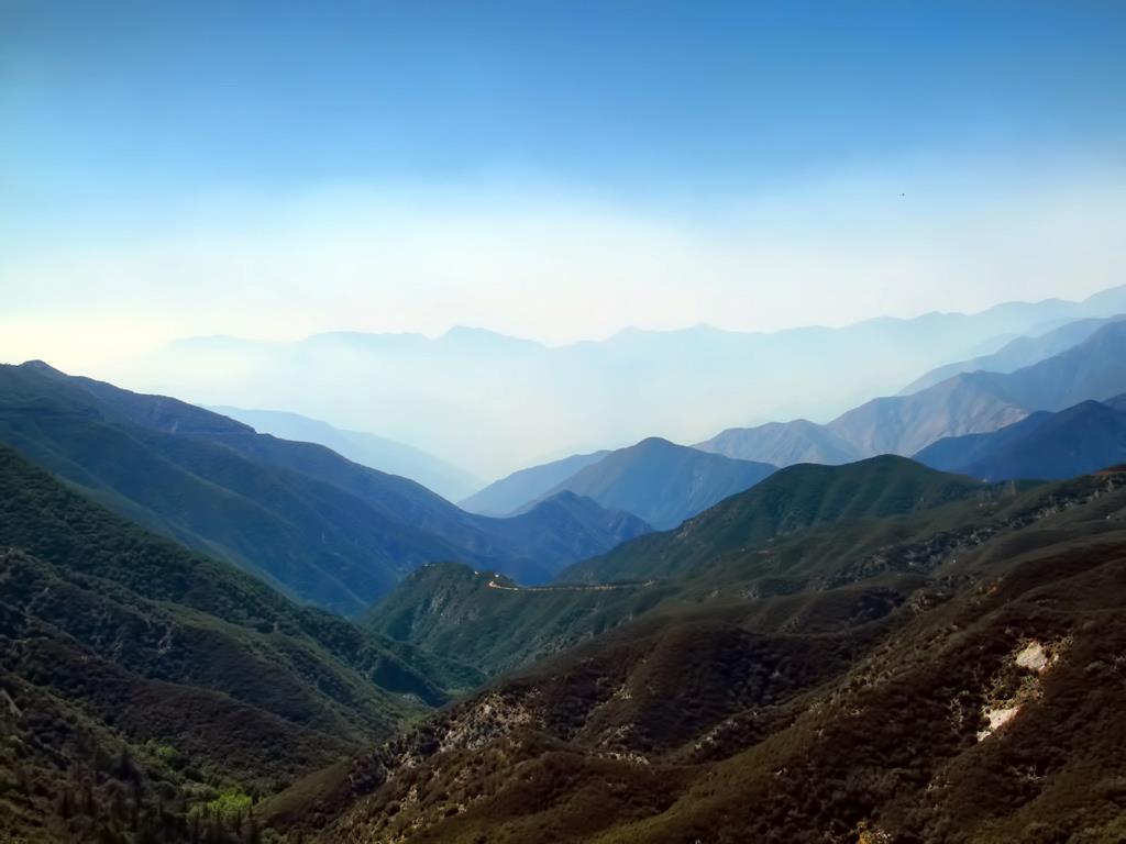
The trail is mostly hot and exposed but after a while, you end up in the canyon among some big ass trees next to a stream in bear-friendly territory. At some point, you have to leave the "trail" and head straight up to get out of the canyon. (Sorry, that's about as detailed as I can get. Bring a map.)

Enjoy the shade.

When it starts to look like this again, you're almost there.

No more shade.

The peak doesn't have the greatest views, but it does have some impressive history. A couple of dudes went up there in the 20s and measured the speed of light.

Science.

If you're one of those creepers who crushes on Mt. Baldy, Lookout Mountain is a good place to sit and stare.

*drool*

Instead of heading back the way we came, we tried to find a route toward Cow Canyon Saddle, but never found it and ended up sand surfing our way down the mountain. Eventually, you'll find a sort of maintained-ish trail that takes you to the saddle. Parts of this trail are just completely gone and aren't particularly safe, but if you survive you'll end up at Cow Canyon Saddle staring at a bunch of oddly placed tractor tires.

Weirdness courtesy of the Monrovia fire
From there, we just walked down Glendora Ridge Road back to Baldy Village.

Monday, July 22, 2013

Sugarloaf and Ontario Peaks via Falling Rock Canyon - 7/20/13

We've been wanting to try Sugarloaf for a long time, but for some reason we thought it was enough of a rock fall hazard that we'd need helmets. We looked through some trip reports the day before our hike and realized that the helmets were only necessary for winter climbing. This report is for a summer hike. If you're planning to try this in the winter, go read someone else's report first.

As usual, this hike comes with warnings. It's called Falling Rock Canyon for a reason, so don't follow too close behind the person in front of you. And whatever you do, DON'T TOUCH THE STINGING NETTLES.

This is a stinging nettle. You'll thank me later.
The trail starts out at Icehouse Canyon and follows the main trail for about 1/4 mile. At that point, you should cross over to the other side of the creek. You'll find Falling Rock Canyon behind the ruins about 1/2 a mile past the Icehouse trailhead; it's the first canyon on the south side of the creek. Look for the cairns.


I was under the impression that the entire climb would be class 3, but there are really just a few short class 3 sections. Go slowly, hold on tight, don't look down. I don't think a fall would be deadly, but you'd be in pretty bad shape.


If you find yourself at a point where you can safely turn around, look behind you and enjoy an unusual view of Mt. Baldy.


About a mile into the canyon, you'll turn right and head straight up a rocky scree slope. This part is steep and annoying, but it's only about 1/4 of a mile. Once you get to the saddle between Sugarloaf and Ontario, there isn't much more climbing left to do.


Scree Slope

From the saddle, head north about 1/2 a mile and you'll find yourself on top of Sugarloaf Peak. Just over 2 miles and about 2000' of gain up to this point. The view of Baldy from the 6,924' summit is a nice one as usual, but Telegraph steals the show. Stats aside, Telegraph appears more prominent than any other peak around.

Telegraph showing off

Once you get back to the saddle, you have the option to scree surf your way back down the canyon, or you can keep going toward Ontario Peak.

A use trail appears for stretches as you climb your way up the ridge to Ontario, and someone went wild with the cairns on this route, so there's not much routefinding to do.

There's a lot of this

When you get to the trail-less section full of manzanitas, whitethorn, and dead trees, you're almost there. You'll meet up with the Ontario trail and then there's less than 1/4 mile to go before you reach the summit. The whole climb is just 4.5 miles and about 4200' of gain.

Manzanitas, whitethorn, and dead trees

You could go back the way you came if you really want to avoid Icehouse Highway, but the 6 miles back down the main trail is probably more pleasant, especially if you get treated to a nice summer drizzle like we did.